 Geosur
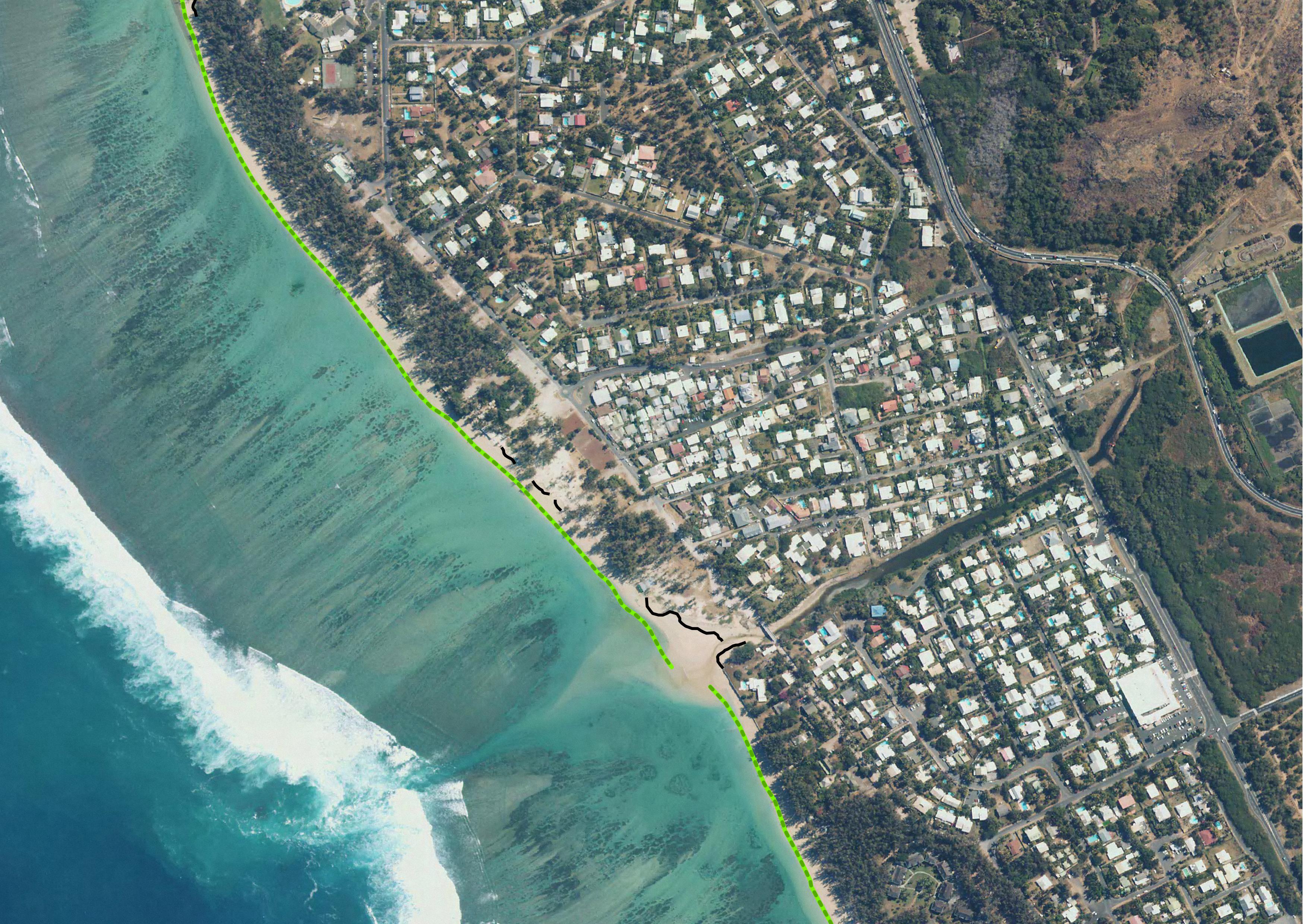
National Observation Service Dynalit, focuses on Coastline by BD ORTHO®, Reunion Island
SNO Dynalit "Trait de Côte" BD ORTHO®, Ile de la Réunion
Vorlage für die Vektor-Daten in ISO19139 (mehrsprachig)
模板矢量数据ISO19139(多种语言)
نموذج البيانات الموجهة في ISO19139 (متعددة اللغات)
De plantilla para el vector de datos en ISO19139 (multilingüe)
Шаблон для векторных данных в ISO19139 (многоязычное)
The coastline or shoreline is the geographical boundary between sea and land. It corresponds according to the SHOM to "the leash of the highest seas in the context of an astronomical tide of coefficient 120 and under normal weather conditions (without overcost phenomenon). The coastline as defined above is not directly identifiable continuously on the ground or on a satellite or aerial image. From a perspective of studying the displacement of the shoreline, indicators allow us to approach this notion (the vegetation limit associated with the infrastructure limit, the beach limit, etc.).
On the reef shoreline of Reunion Island the limit of vegetation and infrastructure as well as beach limit were retained. This limit results in the production of a line-type vector geographic information layer in a GIS resulting from photo-interpolation on the orthophotos of IGN also called BD ORTHO. BD ORTHO is a component of the RGE®. These are digital color orthophotos supplied in raster format (tiff, ecw, ..). An orthophotography is a digital image that has the same metrics as a map of the same projection for the same elements on the ground. They have been available since 1997 in Réunion with a five-year repeatability. Their spatial resolution increased from 1 m in 1997 to 50 cm in 2003.
UMR Espace-Dev
Le trait de côte ou la ligne de rivage est la limite géographique entre mer et terre. Il correspond d’après le SHOM à « la laisse des plus hautes mers dans le cadre d'une marée astronomique de coefficient 120 et dans des conditions météorologiques normales (sans phénomène de surcôte). Le trait de côte tel que défini ci-dessus n'est pas directement repérable de façon continue sur le terrain ou sur une image satellite ou aérienne. Dans une perspective d’étudier le déplacement du rivage des indicateurs permettent d’approcher cette notion (la limite de végétation associée à la limite des infrastructures, le pied de plage,….).
Sur le littoral récifal de l’île de La Réunion la limite de végétation et d’infrastructure ainsi que de pied de plage ont été retenue. Cette limite se traduit par la production d’une couche d’information géographique vecteur de type ligne dans un SIG résultat de la photo-interpétration sur les orthophotographies de l’IGN aussi appelées BD ORTHO. La BD ORTHO est une composante du RGE®. Il s’agit d’orthophotographies numériques couleurs fournies au format raster (tiff, ecw,..). Une orthophotographie est une image numérique qui a les mêmes qualités métriques qu’une carte de même projection pour les mêmes éléments au sol. Elles sont disponibles depuis 1997 sur La Réunion avec une répétitivité quinquennale. Leur résolution spatiale est passée de 1 m en 1997 à 50 cm en 2003.
UMR Espace-Dev
Simple
-
Date (Création)Datum (Erstellung)Date (Creation)Date (Creation)Fecha (Creación)Дата (создания)Date (Creation)
- 2012-01-01T00:00:00
-
Forme de la présentationPräsentationsformPresentation formPresentation formFormulario de presentaciónФорма представленияPresentation form
-
Carte numériqueDigitale KarteDigital mapDigital mapMapa digitalцифровая картаDigital map
-
ButZweckPurposePurposePropósitoНазначение набора данныхPurpose
- Réaliser des profils topographiques de 39 plages de la Réunion
-
EtatBearbeitungsstatusStatusStatusEstadoСтатусStatus
-
En cours de créationIn ErstellungUnder developmentUnder developmentBajo desarrolloв разработкеUnder development
-
Fréquence de mise à jourÜberarbeitungsintervallMaintenance and update frequencyMaintenance and update frequencyMantenimiento y frecuencia de actualizaciónЧастота обновленияMaintenance and update frequency
-
Lorsque nécessaireBei BedarfAs neededAs neededA discreciónпо необходимостиAs needed
-
ThèmeThemaThemeThemeTemaпредметTheme
-
-
ElevationAltitude
-
Reefal beachPlage récifal
-
BD ORTHO®BD ORTHO®
-
DynalitDynalit
-
SNO "Traît de côte", littoral managementSNO "Traît de côte, aménagement des littoraux"
-
-
LocalisationOrtPlacePlaceLugarместоPlace
-
-
Indian OceanOcéan Indien
-
Reunion islandIle de la Réunion
-
-
Contraintes d'accèsZugriffseinschränkungenAccess constraintsAccess constraintsRestricciones de AccesoОграничения на получениеAccess constraints
-
RestreintBeschränkter ZugangRestrictedRestrictedRestrictedограничения раскрытия информацииRestricted
-
Contraintes d'utilisationNutzungseinschränkungenUse constraintsUse constraintsRestricciones de usoОграничения на использованиеUse constraints
-
RestreintBeschränkter ZugangRestrictedRestrictedRestrictedограничения раскрытия информацииRestricted
-
Type de représentation spatialeRäumliche DarstellungsartSpatial representation typeSpatial representation typeTipo de representación espacialТип пространственного представленияSpatial representation type
-
VecteurVektorVectorVectorVectorвекторVector
-
Dénominateur de l'échelleMassstabszahlDenominatorDenominatorDenominadorЗнаменатель масштабаDenominator
- 1
-
LangueSpracheLanguageLanguageIdioma del metadatoЯзыкMetadata language
- English
-
Jeu de caractèresZeichensatzCharacter setCharacter setCodificaciónКодировкаCharacter set
-
Utf8Utf8UTF8UTF8UTF8utf8UTF8
-
Catégorie ISOThematikTopic categoryTopic categoryCategoría temáticaПредметная областьTopic category
-
-
Informations géoscientifiquesGeowissenschaftenGeoscientific informationGeoscientific informationInformación geocientíficaДанные наук о ЗемлеGeoscientific information
-
AltitudeHöhenangabenElevationElevationElevaciónРельефElevation
-
- Begin date
- 1997
- End date
- en cours...
))
-
Nom du système de référenceIdentifikator des ReferenzsystemsReference system identifierReference system identifierIdentificador del Sistema de ReferenciaReference system identifierReference system identifier
-
EPSG : 4326IGNF : RGR92UTM40S
-
Ressource en ligneOnlineOnLine resourceOnLine resourceRecurso en líneaОнлайновый ресурсOnLine resource
-
vegetation limit Limite de vegetation
(
WWW:LINK-1.0-http--link
)
TC Saint-Gilles Reef - BD ORTHO - vegetation limit
-
Ressource en ligneOnlineOnLine resourceOnLine resourceRecurso en líneaОнлайновый ресурсOnLine resource
-
beach limit pied de plage
(
WWW:LINK-1.0-http--link
)
TC Saint-Gilles Reef - BD ORTHO - Beach LimitTC Saint-Gilles Reef - BD ORTHO - Beach Limit
-
NiveauBezugsebeneHierarchy levelHierarchy levelJerarquíaИерархический уровеньHierarchy level
-
Jeu de donnéesDatenbestandDatasetDatasetConjunto de datosнабор данныхDataset
-
Identifiant de la ficheMetadatensatzidentifikatorFile identifierFile identifierIdentificador del ficheroИдентификатор файлаFile identifier
- 1db1604b-bfbc-4312-8c6f-dc7b10ebb78d XML
-
LangueSpracheLanguageLanguageIdioma del metadatoЯзыкMetadata language
- English
-
Jeu de caractèresZeichensatzCharacter setCharacter setCodificaciónКодировкаCharacter set
-
Utf8Utf8UTF8UTF8UTF8utf8UTF8
-
Date des métadonnéesDatumDate stampDate stampFechaВремя создания метаданныхDate stamp
- 2021-10-28T12:18:25
- Metadata standard name
- ISO 19115:2003/19139
- Metadata standard version
- 1.0
Overviews

Spatial extent
Provided by