
ESPOIRS Project
The overall objective of the ESPOIRS project is to obtain a better understanding of the variability, statistical properties and formation mechanisms of intense tropical precipitation at regional and local scales.
ESPOIRS is thus interested in the entire life cycle of precipitation at several space-time scales.
* Through the analysis of the distribution of the large-scale humidity field which drives the formation of precipitation at the regional scale using a GNSS network.
* Through the characterization of internal (dynamics, microphysics) and external (interactions with the relief) processes, which drive the formation and life cycle of extreme weather events at the local scale => transportable Polarized Doppler X-band precipitation radar.
Simple
- Date (Publication)
- Purpose
-
Strategy:
ESPOIRS is part of a global scientific strategy, initiated several years ago by LACy, the University of La Réunion and their regional and national partners, aimed at:
Improve the understanding, forecasting and space-time variability of extreme weather events and their impacts in the South West Indian Ocean (SWIO) sub-region;
Better anticipate and characterize the evolution of these events in a context of climate change and territorial resilience;
Strengthen scientific and technical collaboration, training, and regional expertise in the field of meteorology and remote sensing;
Contribute to strengthening the means of meteorological observations in the SWIO region in collaboration with the meteorological research centers of this region
Implementations:
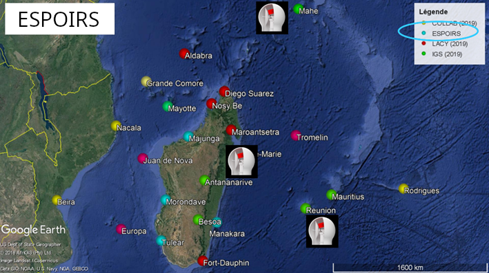
Study and analysis of the space-time distribution of the water vapor field at regional and local scales by GNSS measurements: deployment of 4 additional stations to expand the OI network around Madagascar
Study of the mechanisms of formation and transformation of intense precipitation at the local scale in interaction with the relief: acquisition and deployment of a double polarization Doppler X-band precipitation radar (GAMIC MWR-25-DP) in Reunion, the Seychelles and Madagascar.
Steering, training and promotion actions in cooperation with regional partners.
Action 1:
1.1: Study of the water cycle at the regional scale
1.2: Study of the water cycle at the local scale
The first action aims to improve our understanding of the water cycle in the SWIO basin in order to better understand its impact on the formation of precipitation at regional and, to a lesser extent, local scales.
This action is essentially based on the use of observations collected by the GNSS water vapor observation network deployed by LACy and its partners throughout the Indian Ocean.
Action 2:
2.1: Acquisition of fine-scale radar observations
2.2: Study of the impact of relief on the intensity and distribution of precipitation at the local scale
2.3: Development of new decision support and crisis management tools
The second action aims to improve our understanding of the mechanisms of formation of intense precipitation at the local scale by precisely documenting the physical and statistical properties of the precipitating systems on three distinct islands with very marked relief (Réunion, Mahé-Seychelles, Madagascar).
This action is based on the implementation of a dedicated cloud and precipitation observation strategy based on a new unique X-band precipitation radar in the SWIO region.
Action 3:
3.1: Project management
3.2: Training
3.3: Promotion of scientific work
The third action aims to strengthen regional expertise in the field of remote sensing and tropical meteorology in collaboration with LACy partner universities in the Indian Ocean area.
It is based on the implementation of training and teaching actions, backed by communication actions aimed at the general public and the scientific community, making it possible to strengthen research capacities in the SWIO sub-region.
It also aims to provide territorial managers with leads for the definition of innovative decision-making support tools.
Partners
Seychelles Meteorological Authority
Direction Générale de la Météorologie
Direction Inter-Régionale Océan Indien
Institut Supérieur de Technologie d’Antsiranana
Ecole Supérieure Polytechnique d’Antananarivo
Acknowledgements:
This work is part of the INTERREG V ESPOIRS project (Study of Precipitating Systems in the Indian Ocean by Radar and Satellites). The ESPOIRS scientific program is led by LACy (University of La Réunion / CNRS / Météo France) and funded by the European Union (FEDER program - GURDTI/20201589-0021087), the Réunion Region, SGAR-Réunion, the State (CPER) and the University of La Réunion.
- Status
- On going
- Point of contact
-
Organisation name Individual name Electronic mail address Role LACy
Joël Van Baelen
Owner LACy
Guillaume Lesage
Point of contact
- Maintenance and update frequency
- As needed
- Metadata author
-
Organisation name Individual name Electronic mail address Role LACy
Guillaume Lesage
Point of contact
- Discipline
-
-
remote sensing
-
radar
-
GNSS
-
water vapor
-
- Place
-
-
Weather
-
Precipitation
-
-
Continents, countries, sea regions of the world.
-
-
Indian Ocean
-
- Access constraints
- Copyright
- Use constraints
- otherRestictions
- Language
-
fre
- Character set
- UTF8
- Topic category
-
- Climatology, meteorology, atmosphere
- Begin date
- 2021-09-01
- End date
- 2023-12-31
))
- Reference system identifier
- WGS 1984
- Number of dimensions
- 3
- Cell geometry
- Area
- OnLine resource
- Hierarchy level
- Feature
Metadata
- File identifier
- 4852ab1c-d3a9-408e-863b-0b935bcad844 XML
- Metadata language
- English
- Character set
- UTF8
- Date stamp
- 2023-10-04T05:41:21
- Metadata standard name
-
ISO 19115:2003/19139
- Metadata standard version
-
1.0
- Metadata author
-
Organisation name Individual name Electronic mail address Role LACy
Guillaume Lesage
Point of contact
Citation proposal
Joël Van Baelen (LACy), & Guillaume Lesage (LACy).
ESPOIRS Project (Version http://localhost:8080/demodem/editioin) [Jeu de données].
https://geosur.osureunion.fr/geonetwork/srv/api/records/4852ab1c-d3a9-408e-863b-0b935bcad844






)))