 Geosur
OSU-Réunion, UAR3365
Type of resources
Available actions
Topics
INSPIRE themes
Keywords
Contact for the resource
Provided by
Years
Formats
Representation types
Update frequencies
status
Scale
-

The beach profile is a sectional representation of its topography. The beach topography and its dynamics (by beach profile or transect approach) is illustrated by the acquisition of altimetry data along a fixed profile. 42 profiles are regularly monitored on the reef coast of Reunion Island: 2 profiles per year before the swell seasons of summer and austral winter; the impact of the events of strong swells (cyclones, southern swells) is systematically measured on the labeled Dynalit sites and more sporadically on the other sites. The methodology deployed locally since 2012.
-

The dataset of the first observatory from the French network of critical zone observatories (OZCAR) located in an insular tropical and volcanic context, integrating a “Tropical Montane Cloud Forest”: The ERORUN-STAFOR observatory. This collaborative observatory is located in the northern part of La Réunion island (Indian Ocean) within the watershed of Rivière des Pluies (45.0 km²) which hosts the TMCF of Plaines des Fougères, one of the best preserved natural habitats in La Réunion Island. Since 2015, the ERORUN-STAFOR monitoring in collaboration with local partners collected a multidisciplinary dataset with a constant improvement of the instrumentation over time. At the watershed scale and in its vicinity, the ERORUN-STAFOR observatory includes 10 measurement stations covering the upstream, midstream and downstream part of the watershed. The stations record a total of 48 different variables through continuous (sensors) or periodic (sampling) monitoring. The dataset consists of continuous time series variables related to (i) meteorology, including precipitation, air temperature, relative humidity, wind speed and direction, net radiation, atmospheric pressure, cloud water flux, irradiance, leaf wetness and soil temperature (ii) hydrology, including water level and temperature, discharge and electrical conductivity (EC) of stream, (iii) hydrogeology, including groundwater level, water temperature and EC in two piezometers and one groundwater gallery completed by soil moisture measurements under the canopy. The dataset is completed by periodic time series variables related to (iv) hydrogeochemistry, including field parameters and water analysis results. The periodic sampling survey provides chemical and isotopic compositions of rainfall, groundwater, and stream water at different locations of this watershed. The ERORUN-STAFOR monitoring dataset extends from 2014 to 2022 with an acquisition frequency from 10 min to hourly for the sensor variables and from weekly to monthly frequency for the sampling. Despite the frequent maintenance of the monitoring sites, several data gaps exist due to the remote location of some sites and instrument destruction by cyclones. This observatory is a unique research site in an insular volcanic tropical environment offering three windows of observation for the study of critical zone processes through upstream-midstream-downstream measurements sites. This high-resolution dataset is valuable to assess the response of volcanic tropical watersheds and aquifers at both event and long-term scales (i.e. global change). It will also allow various progress in understanding the significant role of the TMCFs in the recharge processes, the hydrogeological conceptual model of volcanic islands, the watershed hydrosedimentary responses to extreme climatic events and their respective evolution under changing climatic conditions.
-
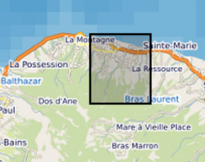
The ERORUN-STAFOR Observatory Data Management Plan (DMP) is related to the French network of critical zone observatories (OZCAR) located in an insular tropical and volcanic context, integrating a “Tropical Mountain Cloud Forest '' (TMCF). This collaborative observatory is located in the northern part of Réunion island (Indian Ocean) within the watershed of Rivière des Pluies (45.0 km²) which hosts the TMCF of Plaines des Fougères, one of the best preserved natural habitats in Réunion Island. Since 2015, the ERORUN-STAFOR monitoring in collaboration with local partners collected a multidisciplinary dataset with a constant improvement of the instrumentation over time. At the watershed scale and in its vicinity, the ERORUN-STAFOR Observatory includes 10 measurement stations covering the upstream, midstream and downstream part of the watershed. The stations record a total of 48 different variables through continuous (sensors) or periodic (sampling) monitoring. The dataset consists of continuous time series variables related to (i) meteorology, including precipitation, air temperature, relative humidity, wind speed and direction, net radiation, atmospheric pressure, cloud water flux, irradiance, leaf wetness and soil temperature, (ii) hydrology, including water level and temperature, discharge and electrical conductivity of stream, (ii) hydrogeology, including groundwater level, water temperature and electrical conductivity in two piezometers and one groundwater gallery completed by soil moisture measurements under the canopy. The database is completed by periodic time series variables related to (iv) hydrogeochemistry, including field parameters and water analysis results. The periodic sampling survey provides chemical and isotopic compositions of rainfall, groundwater, and stream water at different locations of this watershed. The ERORUN-STAFOR monitoring database extends November 2014 to April 2022 with an acquisition frequency from 10 min to hourly for the sensor variables and from weekly to monthly frequency for the sampling. Despite the frequent maintenance of the monitoring sites, several data gaps exist due to the remote location of some sites and instrument destruction by extreme events such as cyclones. This observatory is a unique research site in an insular volcanic tropical environment offering three windows of observation for the study of critical zone processes through upstream-midstream-downstream measurements sites. This high-resolution database is valuable to assess the response of volcanic tropical watersheds and aquifers at both event and long-term scales (i.e. global change). It will also allow various progress in understanding the significant role of the TMCF in the recharge processes, the hydrogeological conceptual model of volcanic islands, the watershed hydro sedimentary responses to extreme climatic events and their respective evolution under changing climatic conditions.
-
ReefTEMPS is a network created by the IRD, initially covering some twenty territories and island states in the South, South-West and West Pacific. ReefTEMPS-OI is the Indian Ocean version. The network uses temperature, pressure, salinity and other coastal observables to monitor climate change and its effects on coral reefs and their resources over the long term. ReefTEMPS is part of the French national federative Research Infrastructure for coastal ocean and seashore observations named IR I-LICO, accredited as a National Observation Service (SNO) by the CNRS-INSU Ocean-Atmosphere Commission. ReefTEMPS is operated by ENTROPIE since 2019. Previously, it was created and led by GOPS (a consortium of research observatories in the South Pacific) during the period 2010-2017, then coordinated by UMR LEGOS in 2018. ReefTEMPS-OI, its Indian Ocean version, is operated by OSU-Réunion since 2020.