 Geosur
environment
Type of resources
Available actions
Topics
INSPIRE themes
Keywords
Contact for the resource
Provided by
Years
Formats
Representation types
Update frequencies
status
Scale
-

The dataset of the first observatory from the French network of critical zone observatories (OZCAR) located in an insular tropical and volcanic context, integrating a “Tropical Montane Cloud Forest”: The ERORUN-STAFOR observatory. This collaborative observatory is located in the northern part of La Réunion island (Indian Ocean) within the watershed of Rivière des Pluies (45.0 km²) which hosts the TMCF of Plaines des Fougères, one of the best preserved natural habitats in La Réunion Island. Since 2015, the ERORUN-STAFOR monitoring in collaboration with local partners collected a multidisciplinary dataset with a constant improvement of the instrumentation over time. At the watershed scale and in its vicinity, the ERORUN-STAFOR observatory includes 10 measurement stations covering the upstream, midstream and downstream part of the watershed. The stations record a total of 48 different variables through continuous (sensors) or periodic (sampling) monitoring. The dataset consists of continuous time series variables related to (i) meteorology, including precipitation, air temperature, relative humidity, wind speed and direction, net radiation, atmospheric pressure, cloud water flux, irradiance, leaf wetness and soil temperature (ii) hydrology, including water level and temperature, discharge and electrical conductivity (EC) of stream, (iii) hydrogeology, including groundwater level, water temperature and EC in two piezometers and one groundwater gallery completed by soil moisture measurements under the canopy. The dataset is completed by periodic time series variables related to (iv) hydrogeochemistry, including field parameters and water analysis results. The periodic sampling survey provides chemical and isotopic compositions of rainfall, groundwater, and stream water at different locations of this watershed. The ERORUN-STAFOR monitoring dataset extends from 2014 to 2022 with an acquisition frequency from 10 min to hourly for the sensor variables and from weekly to monthly frequency for the sampling. Despite the frequent maintenance of the monitoring sites, several data gaps exist due to the remote location of some sites and instrument destruction by cyclones. This observatory is a unique research site in an insular volcanic tropical environment offering three windows of observation for the study of critical zone processes through upstream-midstream-downstream measurements sites. This high-resolution dataset is valuable to assess the response of volcanic tropical watersheds and aquifers at both event and long-term scales (i.e. global change). It will also allow various progress in understanding the significant role of the TMCFs in the recharge processes, the hydrogeological conceptual model of volcanic islands, the watershed hydrosedimentary responses to extreme climatic events and their respective evolution under changing climatic conditions.
-
Le projet a pour objectif d'améliorer le signal de la pluie détectée par les géophones en comparant les données météorologiques d'un disdromètre, d'un pluviomètre et de 3 géophones afin d'extraire des données des sismographes pour mieux comprendre le transport sédimentaire issu du réseau sismologique installé dans la rivière des pluies et la rivière du Mat. Les objectifs sont : 1) déterminer les caractéristiques sismiques de la pluie sur le site de mesures 2) A terme, comprendre le déclenchement des éboulements et glissements liés aux pluies A court terme, ce projet devrait aussi permettre de : 1) comprendre pour un même type de pluie l'influence de sols de rugosités différentes sur les signaux enregistrés par les sismomètres 2) intégrer/contraindre pour un même type de sol l'influence de types de pluies différentes sur les enregistrements des sismomètres 3) déterminuer l'influence des tailles des gouttes et du nombre de gouttes (indications données par le disdromètre) sur le signal sismique
-

The resource provides two land cover maps of Réunion Island for the years 1950 and 2022 derived from the analysis of ortho-photographs at the island scale (Source IGN). The produced typology uses five cover classes: forest, low vegetation, agriculture, urban, and shadow (related to topography). The method used is based on encoding the two aligned rasters, converted into a single band of grayscale for 2022, using a vision-transformer deep learning model. From the features calculated for each pixel, a random forest classification model is trained separately for each year using a set of ROIs (Regions Of Interest), target polygons delineated within each of the selected classes through photo-interpretation of the original images. Model validation is performed on independent sets of polygons also defined by photo-interpretation. The maps provided in the resource are derived from the prediction of cover classes for both years using the trained and validated models. These are raw predictions, meaning that no post-processing has been applied to reduce potential noise due to classification errors. The shared resource is part of the results from the FRAG'ILE research and development program (FRAGmentation en milieu InsuLairRE, UR / CBNM/ IRD, funded by OFB, https://fragile.frama.io).
-
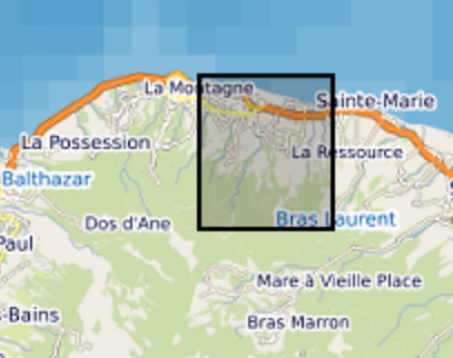
Rain gauge measurements in watershed "Rivière des Pluies", Reunion Island 2 types of rain gauge: - Pluviographe: rain gauge with tipping (0,2 mm). Location: Piton Fougères - Adding rain gauges which is applied the chemistry water protocol. Location: Piton Fougères and University (Moufia-Saint Denis) Laboratoire Géosciences Réunion – IPGP
-

Piezometer measurements in watershed "Rivière des Pluies", Reunion Island Continuous measures in groundwater: - Level water (systematically) - Temperature (sometimes) - Conductivity (sometimes) Laboratoire Géosciences Réunion – IPGP
-

Meteo station Vantage Pro 2 Recorded parameters: - Wind speed and direction - Pluviometer - Temperature - Humidity (inside shelter) and outside - Barometric pressure Data transmission towards station of acquisition via WiFi. This station is connected on a PC Windows software.
-

Instrumentation in river. The parameters are the following ones: - water level (available) - Temperature (available) - Conductivity (to set up) - Turbidity (available) - pH / dissolved oxygen / Potential oxydo-reduction (to set up) Laboratoire Géosciences Réunion – IPGP
-

The ERORUN-STAFOR Observatory Data Management Plan (DMP) is related to the French network of critical zone observatories (OZCAR) located in an insular tropical and volcanic context, integrating a “Tropical Mountain Cloud Forest '' (TMCF). This collaborative observatory is located in the northern part of Réunion island (Indian Ocean) within the watershed of Rivière des Pluies (45.0 km²) which hosts the TMCF of Plaines des Fougères, one of the best preserved natural habitats in Réunion Island. Since 2015, the ERORUN-STAFOR monitoring in collaboration with local partners collected a multidisciplinary dataset with a constant improvement of the instrumentation over time. At the watershed scale and in its vicinity, the ERORUN-STAFOR Observatory includes 10 measurement stations covering the upstream, midstream and downstream part of the watershed. The stations record a total of 48 different variables through continuous (sensors) or periodic (sampling) monitoring. The dataset consists of continuous time series variables related to (i) meteorology, including precipitation, air temperature, relative humidity, wind speed and direction, net radiation, atmospheric pressure, cloud water flux, irradiance, leaf wetness and soil temperature, (ii) hydrology, including water level and temperature, discharge and electrical conductivity of stream, (ii) hydrogeology, including groundwater level, water temperature and electrical conductivity in two piezometers and one groundwater gallery completed by soil moisture measurements under the canopy. The database is completed by periodic time series variables related to (iv) hydrogeochemistry, including field parameters and water analysis results. The periodic sampling survey provides chemical and isotopic compositions of rainfall, groundwater, and stream water at different locations of this watershed. The ERORUN-STAFOR monitoring database extends November 2014 to April 2022 with an acquisition frequency from 10 min to hourly for the sensor variables and from weekly to monthly frequency for the sampling. Despite the frequent maintenance of the monitoring sites, several data gaps exist due to the remote location of some sites and instrument destruction by extreme events such as cyclones. This observatory is a unique research site in an insular volcanic tropical environment offering three windows of observation for the study of critical zone processes through upstream-midstream-downstream measurements sites. This high-resolution database is valuable to assess the response of volcanic tropical watersheds and aquifers at both event and long-term scales (i.e. global change). It will also allow various progress in understanding the significant role of the TMCF in the recharge processes, the hydrogeological conceptual model of volcanic islands, the watershed hydro sedimentary responses to extreme climatic events and their respective evolution under changing climatic conditions.
-

Weekly and monthly physico-chemical water samples of "Rivière des Pluies" watershed, Reunion Island
-
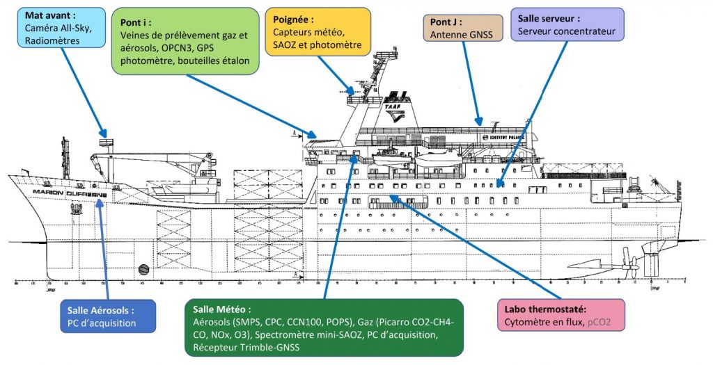
Le projet MAP-IO vise à effectuer des observations atmosphériques et de biologie marine sur le long terme dans la région de l’ouest de l’océan Indien. Ces données seront bancarisées en open-source à la fois dans les réseaux internationaux (ICOS, ACTRIS) qui sont utilisés pour initialiser et valider les modèles climatiques du GIEC et les satelittes et sur la base de données GeOSUR dédiée à la recherche et à l’ensemble des acteurs du territoire. Elles permettront d’avancer sur notre compréhension des échanges océan-atmosphère, sur la pollution régionale et sur les mécanismes chimiques en permettant d’améliorer et d’adapter les paramétrisations utilisées dans les modèles numériques de prévision du temps et de climat sur la région ouest de l’océan Indien. La stratégie de MAP-IO s’inscrit dans la continuité et la valorisation des investissements de la région Réunion en renforçant les bases de données des programmes scientifiques ReNovRisk Cyclones et Changement Climatique (INTERREG V) et UV-INDIEN (INTERREG V) et l’infrastructure « Observatoire du Maïdo » (FEDER). MAP-IO viendra renforcer la place de la Réunion dans les grandes infrastructures de recherches Européenne ACTRIS (http://www.actris.fr/) et ICOS (https://www.icos-france.fr/). A terme, l’objectif est de faire de La Réunion un hub de surveillance du climat et des changements globaux de niveau international permettant une percolation des produits de recherche vers l’activité économique et sociétal du territoire. MAP-IO s’inscrit également dans une action forte de La Réunion pour la croissance bleue dans les DOM (livre bleu de l’outre-mer, 2018). MAP-IO se positionne dès à présent dans les lignes directrices de la mission 3 du programme Horizon Europe (2021-2027) « Santé des océans et des eaux naturelles » et au sein des partenariats institutionnels du domaine 3 « Leadership européen dans le domaine de la métrologie, y compris un système intégré de métrologie ». Ce positionnement ouvrira des nouvelles opportunités de réponses des scientifiques de La Réunion aux appels d’offres au programme européen pour la recherche et l'innovation (Horizon Europe). Questions de recherche L’objectif du projet MAP-IO est d’étudier la composition de l’atmosphère et les processus océan-atmosphère ayant un impact sur le climat régional et la prévision numérique du temps. Ce programme scientifique s’appuie sur la bancarisation de données océaniques et atmosphériques en équipant le navire Marion Dufresne de plusieurs systèmes de mesure de l’atmosphère pérennes et autonomes. Ces systèmes d’observations ont cinq buts principaux: - Documenter l’état de surface océanique et la composition biologique en phytoplancton ; données permettant de participer à la calibration des données satellites et à la validation des modèles océaniques et biologiques sur l’océan Indien et austral. - Surveiller les changements atmosphériques globaux en particulier dans la région de l’océan Indien très faiblement documentée (réseaux NDACC, ACTRIS, ICOS). Bancariser les données en open data. - Étudier les transports de masses d’air et la redistribution des aérosols et des composés chimiques dans la troposphère et la stratosphère (programmes IGAC et SPARC). - Documenter les émissions de gaz et d’aérosols marins pour les modèles atmosphériques de prévision numérique ou de climat (programme SOLAS). - Renforcer les réseaux régionaux d’observation du changement climatique régional déployés dans le cadre des programmes ReNovRisk Cyclones et Changement Climatique (INTERREG-V), IOGA4MET (TAAF, AAP Iles Eparses) et UV-indien (INTERREG-V). Actions et méthodes scientifiques Le programme MAP-IO s’est construit autour de deux fiches actions. La fiche action 1 « amélioration de la connaissance » correspond aux études scientifiques qui seront abordées à partir des observations à bord du Marion Dufresne pendant 24 mois. Elle sont déclinés en 5 sous actions. - 1.1 : Distribution spatiale et hétérogénéité structurelle des groupes fonctionnels du phytoplancton et du microzooplancton, couplage avec les images satellite de couleur de l’eau. Mise en œuvre d’un cytomètre en flux. - 1.2 : Échanges océan-atmosphère: aérosols marins et composition de la couche limite marine. Mise en œuvre de mesures in-situ de gaz et d’aérosols. - 1.3 : Climatologie et variabilité des rayonnements UV et de l’ozone dans l’Océan Indien. Mise en œuvre de mesures UV A,B et C et de colonne intégrée d’ozone. - 1.4 : Étude des panaches d’aérosols issus des feux de biomasse et en provenance du Sud de l’Afrique, de l’Amérique du Sud et de l’Asie du Sud-Est. Mise en œuvre d’un photomètre solaire/lunaire pour l’épaisseur optique des aérosols. - 1.5 : Surveillance du champ de vapeur d’eau à l’échelle du bassin SOOI. Mise en œuvre d’un GNSS. La fiche action 2 correspond au management et à la valorisation du programme. Cette action intègre la (i) coordination et la gestion administrative et financière du programme et (ii) une conférence de restitution du programme et d’organisation d’un modèle économique de fonctionnement perenne de MAP-IO. Partenaires MAP-IO intègre une équipe de 17 scientifiques de haut niveau, responsables notamment de plusieurs services nationaux d’observation de l’atmosphère tels que NDACC, CLAP et PHOTON et bien intégrés au sein des infrastructures de recherche Européenne ACTRIS et ICOS. Dans ce cadre MAP-IO permettra de renforcer les liens collaboratifs entre scientifiques issus de 7 laboratoires de métropole et ceux de l’université de La Réunion. Ce réseau de scientifique pourra se densifier si l’université de La Réunion et ses partenaires au travers de MAP-IO montrent leur capacité à maintenir sur le long terme ces observations régulières uniques au monde.